MAPS: GIS Windows
on Native Lands,
Current Places,
and History


Page Buttons


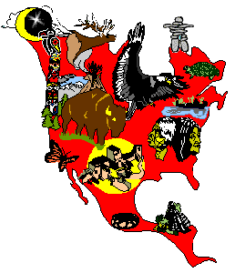
NOTE: All imagemaps here are client-side (browser pull) not server push. All maps, graphics large and small, and tribal data linklists are a great deal of work on my part. ALL OF THEM ARE COPYRIGHT. They may NOT BE DOWNLOADED for use on any other website; link-to, but don't steal them! A few large-screen maps are prepared for classroom printout-handouts. These may be downloaded for THAT PURPOSE ONLY, not for web or print reproduction.

NATIVE GIS -- GIS are Geographical Information Systems, where maps are used as windows to organize and examine data of various kinds that relate to location, to places. Canadian cartography grad student collects some basic explanations of GIS and what some tribes are doing (mostly finding out they can't afford it; been seeing the wrong consultants!) GIS is what I'm doing in a small way here. Best current example of how an info-magagement GIS works will be found in MINNESOTA. (1/23).

  • What is GIS? ESRI, an engineering-consulting firm that specializes in GIS, provides the full scoop. ESRI has about 20 tribal customers, including the Navajo Nation. GIS is expensive, but they'll also help a Native Nation get started with grants of the (very expensive) ArcInfo software, training scholarships and extensive help -- and if need be, a Big Mac and the special scanner needed for the biggest effort, which is the time and efforts required to digitize the local data for a real GIS. A good way for tribes to get started may be through conservation management, using the easier (and much cheaper!) ArcView. ESRI has a conservation program offering get-started grants and training, that they'd like to see more Native Nations and Indian environmental groups get involved in.

  • GIS Implementation Experience in Wisconsin Ho-Chunk Nation -- an article by the former tribal GIS director explains how they got started (with an ESRI grant), what it's being used for in tribal decision-making and planning, and why the implementation succeeded so well.

  • Computer scientist writes on protecting Native Nations from spy satellite GIS data. Colville tribe was denied such data by the BIA

  • EarthSat North American Project Listing -- Here's all the satellite detailed photography projects -- all except the CIA's, which the Navajo Nation recently signed up for.

  • Intertribal GIS Council, a national non-profitÊ Êorganization dedicated to promoting tribal self determination by improving management of geographic information andÊbuilding intertribal communication networks.

British Columbia First Nations GIS Map -- not beautiful, but works very well to provide several kinds of info access on the many First Nations in BC. NOTE: INAC's more complex (and intellectually defective) attempt at a GIS and Bands database has been down since they moved to a dfferent server last year. It probably still exists, but they lost it on their server.


Google

TOP of
Page
MAIN
Menu


Text, maps and graphics copyright -- Paula Giese, 1996. except where elsewhere attributed.

CREDITS:The "putting the Indian Sign on North America" map-graphic was originally designed by Akwesasne Mohawk Jim Berenholz in 1976. It's half of a black and white poster for Awkesasne Notes "Bicentennial". The original also has South America (as does my big AIM poster). In 1993, I spent about 3 weeks tracing this (from an old issue of Notes). I colored it in FreeHand and it was a poster for the AIM 25th anniversary and International Indigenous Peoples' Summit meeting then. I've made some changes in the "signs", to suit the low-rez web, and my desire to animate all parts of RedMap. Additional anis will be done one at a time, to celebrate the completion of major jobs of tribal info-on-line in the tribes-by-statemaps section here. Now pl;aying on the RedMap: "Raven Eats the Impossible Star," a trad legends I made up for the occasion of the ani.

Last Updated: 5/27/97