MAPS: GIS Windows
on Native Lands,
Current Places,
and History


Page Buttons


INDIVIDUAL NATIVE SITES MAPS (and Info)

MIDWEST TREATY NETWORK's Map of Treaty and Claimed Lands in the Great Lakes region, both U.S. and Canadian tribes. Zoltan Grossman, cartographer


SULPHIDE MINING IN WISCONSIN and its threats to Indian lands there, Midwest Treaty Network, Zoltan Grossman cartographer


BIA Division of Energy and Mineral Resources Home Page--See the map project, the BIA is doing to help out energy resource tribes (Osage and Arapaho). They complained when I said looks like it's really to help out oil and gas companies, but that's what I think of this BIA GIS project.

Navajo Reservation Rug Map showing the districts where different designs and patterns of rugs traditionally originated, with photos of each type. Info about where to get a more modern poster "Legacy of Spider Woman", suitable for classroom or home. See also Map of the Navajo Nation, a modern map showing roads, communities, tourist attractions, from the Navajo Nation website.

Wanipigow (Hollow Water) Reserve Native schoolchildren map their Reserve in words and pix. Another Hollow Water Band community (but same school) Manitogan Reserve schoolchildren map their reserve in words and pix.

Reserve indienne Saddle Lake Indian Reserve -- Schoolchildren map their reserve in words and pix. Reserve indienne Goodfish Lake Indian Reserve -- both bands are parts of the Saddle Lake Band Cree, whose Reserve is geographically separated, lying on 2 different lakes in Alberta.


TOP of
Page
MAIN
Menu

Google


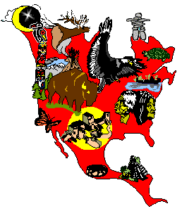
Text, maps and graphics copyright -- Paula Giese, 1996. except where elsewhere attributed.

CREDITS:The "putting the Indian Sign on North America" map-graphic was originally designed by Akwesasne Mohawk Jim Berenholz in 1976. It's half of a black and white poster for Awkesasne Notes "Bicentennial". The original also has South America (as does my big AIM poster). In 1993, I spent about 3 weeks tracing this (from an old issue of Notes). I colored it in FreeHand and it was a poster for the AIM 25th anniversary and International Indigenous Peoples' Summit meeting then. I've made some changes in the "signs", to suit the low-rez web, and my desire to animate all parts of RedMap. Additional anis will be done one at a time, to celebrate the completion of major jobs of tribal info-on-line in the tribes-by-statemaps section here. Now pl;aying on the RedMap: "Raven Eats the Impossible Star," a trad legends I made up for the occasion of the ani.

Last Updated: 5/27/97