Minnesota
BOIS FORT / NETT LAKE Band of CHIPPEWA INDIANS |
 |
|---|---|
|
Federally recognized
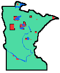
Koochiching, Itasca, Lake and Cook counties, Minnesota Bois Fort consists of 3 pieces of land, of which Nett Lake (village, peninsula, lake and surrounding forest) is by far the largest. The Band's French name means "Strong men (or Strength) of the woods", a name this band was given by the French voyageurs. It lies abnout 75 miles south of the Canadian border. By far the largest land parcel is Nett Lake, where the lake with its fine wild rice beds and awesome Spirit Island are located, is the location of the largest community and the seat of tribal government. Deer Creek, lying to the southeast, is a former allottment parcel in Itasca county, 40 acres that was hung on to, not lost like most allotted lands. Vermillion is on a peninsula in lake Vermillion, lying to the southwest. Its name comes from bright iron oxide, rust in the soils, from the taconite whose post-World War II mining development gave this area the recent name of Minnesota's Iron Range. Its Indian name is Mesabi, the Sleeping Giant. Currently the reservation's Indian-owned land totals 41,863 acres, the remaining acreage within original treaty-determined boundaries.
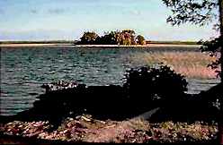
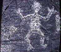
Nett Lake contains wild rice (manoomin) beds that are the largest contiguous ones remaining in the world, covering some 8,000 acres, much of this around Spirit Island. Spirit Island is shown here in late autumn, after the rice harvest, and when the reed beds surrounding it have mostly died back, having re-seeded themselves in August-September for the following spring. Spirit Island gets its name from the Manidoo that have been there since time immemorial; it has always been a sacred place. Rock petroglyphs, and some excavations on the nearby peninsula (where the village of Nett Lake is today) made in the 1940's indicate people were there -- and made the petroglyphs found by the hundreds on the smooth rocks -- thousands of years before Ojibwe people arrived there on the Migration. About 100,000 lbs of wild rice is harvested in the fall, traditionally, by canoes. This is for family use, and is much liked for ceremonial purposes and plain good eating among other Indian families, so some is sold. This rice has not been contaminated by sowing "paddy rice" varieties developed by the University of Minnesota school of agriculture, as has been done at most other reservations. The difference in appearance (and taste) is clear, so Indian people want and eat most of it, leaving the commercial-growth tame or paddy-farmed rice to be sold more cheaply through non-Indian distributors, and tribes involved in paddy rice farming. In 1970, General Mills, a huge international food company headquartered in Minneapolis, sponsored a joint venture that paired Nett Lakers with their Anishinabeg relatives across the Canadian border: a ricing co-op made up of Sabaskong, Eagle Lake, Rat Portage, Wabigoon, Shoal Lake and other Great Lakes bands. Man-O-Min co-op was formed (Manitoba-Ontario-Minnesota, also a word play on manoomin, the Anishinaabemowin name for wild rice; Basil Green, Shoal Lake Ojibwe created the name concept.) Rice was to be harvested in Canada and Nett Lake, trucked across the border (through the International Falls border entry port) to Nett Lake's processing facility and processed there together with the tribe's rice harvest. Then the rice would be trucked to Minneapolis, where it would be packaged and labeled by urban Indian workers hired by the co-op, and sold internationally with General Mills's huge marketing muscle, cxomplete with recipes from the famous Betty Crocker kitchens and cookbook. The plan had every sort of desirable feature for Indian people. The Canadian side of the co-op was based in the town of Kenora. The Canadian Natives were especially glad of this venture, because rice sales were monopolized by a non-indian, Benjamin Ratuski, a crony of Leo Bernier, then Canadian Minister of Natural Resources. Through a network of Reserve stores -- where Natives were given credit to buy necessities against purchase (at a very low price) of their rice harvests, and loaned canoes to make the harvest, to to the food marketing outlets in eastern Canada, Ratuski had it all locked up. As the venture got under way, in its first operating year, 1974, Lake of the Woods Water Control Board (a Canadian government agency) flooded the rice fields by opening dams, citing a sudden need for more hydro power. Of course this killed the rice, so there was no harvest. Band chiefs met at Thunder Bay with Ontario cabinet ministers, trying to explain why this rice venture was so important to their desperately poor Reserves. The ministers said they didn't want a cross-border American venture, and chided the Indians for not seeking Canadian help -- but they had, and had been denied it. Later it was learned that the ministry had furnished Ratowski a $32,000 interest-free loan, and other financial aid at this time. In 1975, the Water Control Board again flooded the Canadian Anishinaabeg rice beds. A government development loan to the Man-O-Min cooperative had its interest raised from 8% to 11% arbitrarily at this time. Reserve town non-Indian store owners -- Ratowski's network for collecting the rice -- refused to give credit for late winter and spring-summer food purchases to families who took part in co-op harvesting, using canoes from other sources. General Mills pulled out of the co-op in late 1975, and it then collapsed. There are very clear indications -- but no legal proof -- that covert agencies of the U.S. government, as well as the Canadian government, were involved in smashing this promising cross-border Native economic venture among close cultural and family relatives, Anishinaabe people, 70% of whom live on the Canadian side of the border the invaders drew across the continent. Bois Fort languished for a decade in economic poverty and internal factionalism (caused by the ways the wild rice venture was governmentally destroyed and covert manipulations of people). Even at present, there is little local economic development activity besides the successful casino. A tribal construction company employs about 6 members seasonally. Bois Fort Sawmill uses tribal holdings of harvestable timber for about 20% of its capacity (this timber is mostly evergreens and aspen), and competes for timber from surrounding public lands timber sales. The sawmill provides jobs for 6 - 12 people. An additional 20 are seasonally employed in 6 private logging businesses.
The tribal councils of Bois Forte and Grand Portage currently compose the governing body of the 1854 Authority, which regulates off-reservation hunting, fishing and gathering rights from the 1854 treaty. A central office is maintained in Duluth, Minnesota. In 1988, negotiations between the Boise Forte, Grand Portage and Fond du Lac Bands and the state of Minnesota resulted in the formation of the 1854 Authority. However, Fond du Lac is no longer a member of the Authority, pursuing its own lawsuit against the state instead. The Authority is discussed in more detail under Grand Portage, whose lawsuit against Minnesota is the reason for the existence of the Authority. carl Gawboy of Nett Lake is a well known painter from Bois Fort. He is gaining an increasing national reputation. He is mentioned in an encyclopedia article about Ojibwe people as one of the outstanding younger artists of the present generation. Unfortunately, I don't have a picture by him to show here (yet). | |
 Fortune Bay Casino opened in December, 1985, on the detached Vermillion parcel, 70 miles from the main reservation, near Tower in the heart of the economically depressed Iron Range. The name is a pun or wordplay on Bois FORT(une). The casino provides jobs for 150 people, some of them tribal members. Its income for the tribe is presently the only economically significant revenue that is not through govenrment programs. The existence of this casino and its tourist draw to the area has helped somewhat to overcome racism directed against Indian people from the local economically depressed mining communities of the area, though there is also jealousy now. Tourism that the tribe is able to benefit from is largely from fall hunting. Nett Lake lies on the northern duck and goose flyway, so there is seasonal supplemental income as hunting guides for some tribal members. Guide service is also provided for deer and moose hunting. Bois Fort has a tribal conservation code that regulates these activities.